EcoSystem Indicator Partnership Monitoring Map
The Gulf of Maine Council’s EcoSystem Indicator Partnership Monitoring Map
 The Gulf of Maine is surrounded by Maine, New Hampshire, Massachusetts, New Brunswick, and Nova Scotia. Its beauty and rich natural resources have drawn people to the region for centuries. The Gulf of Maine has and continues to play a vital role to local jobs and to regional economies (e.g. fishing, tourism, shipping) and in the lives of people that live, work and play there. The importance of the Gulf of Maine means that many organizations have their eye on changes to the health of its environment.
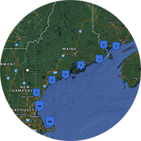
The Gulf of Maine Council’s EcoSystem Indicator Partnership (ESIP) has spent a number of years bringing together information on monitoring organizations that are keeping track of the Gulf of Maine’s environment. This information can be accessed through ESIP’s Monitoring Map (EcoSystem Indicator Partnership website). This exciting webtool brings together information on over 13,000 monitoring sites in the Gulf of Maine. When you look at the whole Gulf of Maine, you can see where monitoring efforts/activities are concentrated. If you zoom into your own location, you can then find out who is monitoring in your own area, what information they are collecting and where you can access the information directly. Visitors can then use that information to find information gaps, important datasets, and organizations to participate in.
For more information on ESIP and this webtool, as well as information on some of ESIP’s other work, check out a 3-minute introductory YouTube video: